
UK weather warning: Britain braces for more thunderstorms and flooding
Written by News on 31/07/2019
Forecasters are warning that more thunderstorms and flooding could be on the way in some parts of the UK.
There was extreme weather at both ends of the spectrum across the country last week, with an immense heatwave that broke the all-time temperature record quickly followed by a deluge of heavy rain.
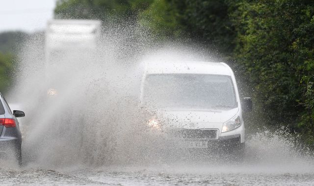
Flooding and travel chaos befell northern areas over the weekend due to the sudden change in conditions, and more of both could be on the cards on Tuesday and Wednesday.
Severe weather warnings have been put in place by the Met Office in England, Wales and Scotland, with thundery downpours, lightning strikes, strong winds and hail all expected.
:: The latest Sky News forecast
Between 20mm (0.8in) and 30mm (1.2in) of rain could fall in just an hour in some areas, which will make for treacherous driving conditions and possible disruption for train passengers.
Power cuts could also be an issue, and there is a “small chance that homes and business could be flooded”.
“Heavy showers and thunderstorms will continue to spread northeast across England and Wales, whilst also increasing in frequency during the day,” the Met Office said.
“In a few places there is the potential for 20mm to 30mm of rain to fall in an hour and 30mm to 50mm (2in) of rain to fall in three hours. Hail is also possible, mainly over northern England.”
The Met Office added: ‘We’ve recently had reports of 50mm of rain in 1 hr in N England…Malham Tarn has seen 68mm in 2hrs’.
Large hail has also been reported across parts of northern England this afternoon.
Showers are still expected on Thursday and Friday, although they will be more scattered than previous days and increasingly confined to the North and East.
It will feel warm in the sunshine, but temperatures will be around average, reaching the low 20s for most. Temperatures of 26C (78.8F) or 27C (80.6F) is possible for southeast England, depending on the amount sunshine.
The weekend looks unsettled too. Saturday will bring sunshine and showers, some thundery, but more general rain will move into the West, with Sunday also looking showery.
Experts say the sudden shifts in weather are being caused by climate change, especially the extreme heatwaves seen in back-to-back summers.
Dr Mark McCarthy, from the Met Office National Climate Information Centre, said: “Historically UK summer heatwaves would typically tend to peak in the low 30s celsius, with extreme events reaching the mid-30s.
“Climate change has increased the likelihood and severity of heatwave episodes across Europe, which will have also increased the risks of a 40C temperature event in the UK.”
Other European countries to have broken their national heat records last week included Belgium and Germany, while the record in France came last month during the Women’s World Cup.
(c) Sky News 2019: UK weather warning: Britain braces for more thunderstorms and flooding