

‘Immediate evacuation’ ordered in town as flood barriers ‘overwhelmed’
Written by News on 27/02/2020
An “immediate evacuation” has been ordered in a town in Shropshire after rising water levels from the River Severn breached flood barriers.
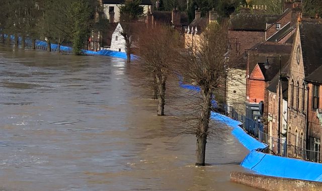
West Mercia Police said it is “currently carrying out an immediate evacuation in Ironbridge due to the temporary barriers becoming overwhelmed”.
Chief Superintendent Tom Harding said the evacuation affected premises on the Wharfage in Ironbridge because water from the River Severn was breaching flood barriers “and in areas it appears it is buckling”.
Councillor Shaun Davies, leader of Telford and Wrekin Council, said the flood barriers were “shunting backwards quite significantly”.
He warned: “Please do not come to Ironbridge. The situation is developing.”
It comes after temporary flood defences in Bewdley in Worcestershire were breached on Tuesday night – with homes being evacuated over fears that the River Severn will not reach its peak until tonight.
The Environment Agency forecasts the river level in the town, which has risen more than two metres in the past 72 hours, will peak at 5.48m on Wednesday and remain at a near-record high into Thursday. It reached its highest level of 5.56m in November 2000.
There are two severe flood warnings in place in Shropshire – indicating a “danger to life” – covering the towns of Shrewsbury and Ironbridge.
According to the Environment Agency, river levels in Ironbridge are expected to remain high for several days.
Boris Johnson has been criticised for his absence from flood-hit areas, with Labour leader Jeremy Corbyn calling him a “part-time prime minister”.
However Mr Johnson insisted he was “very proud” of the government’s response to flooding, saying there had been a “constant stream of ministerial activity” since the latest crisis began.
Network Rail has closed all lines at Shrewsbury station, except for services to and from Chester and Crewe, due to high water levels under the Severn Railway Bridge.
Sky News correspondent Dan Whitehead, who is in Bewdley, said he had seen a sofa and fridge freezer float past him and there was an “immensely strong smell of diesel” from generators overwhelmed by flood water.
“This flood water is going to go up by 15cm or so throughout the day,” he added.
Further showers are expected between now and Friday, and ongoing flooding is also forecast for the next few days.
:: Listen to Sophy Ridge on Sunday on Apple podcasts, Google podcasts, Spotify, Spreaker
Met Office forecaster John Griffiths has said between 5mm and 10mm could fall on the River Severn’s source, the Welsh hills, throughout Wednesday.
The West of England and the Midlands are expected to experience the most frequent showers.
The UK is also braced for snow and ice over the coming days.
Yellow weather warnings for snow and ice have been issued from 10pm on Wednesday to 10am on Thursday across northwest England, eastern England, the Midlands, north Wales, Northern Ireland and the north and west of Scotland.
Forecasters have warned that wintry showers and icy stretches are likely to bring some travel disruption and a risk of injury.
Further yellow warnings for snow are in place across East Anglia, South Wales and the Thames Valley Area on Thursday.
There are also yellow warnings for rain across Wales and northwest England on Friday and Saturday, with a risk of flooding and disruption to transport.
On Tuesday night, residents in Bewdley said they felt “uneasy” as the Severn began to pour over the top of the flood defences.
Adrian Guest said: “I think the fact that the barrier has breached already and the peak is not forecast until this time tomorrow is affecting people’s resolve.
“It feels very different tonight compared to last week when it was originally due to come over last Tuesday.”
Further north, homes were evacuated on Tuesday after the River Aire burst its banks in Snaith, East Yorkshire.
Despite much of the land in the area being washlands – intended to contain river water when it floods – water submerged some roads and began to threaten properties.
Residents were warned by the Environment Agency to put their flood plans into action, although no further significant rainfall is expected there until Friday.
Caroline Douglass, director of incident management at the Environment Agency, said: “We are in our fourth week of exceptional river levels and stormy weather.
“With the effects of climate change, we need to prepare for more frequent periods of extreme weather like this.
“People need to be aware of their flood risk, sign up to flood warnings, make a flood plan and not to drive or walk through floodwater.”
England has seen more than twice its average February rainfall, and some areas have experienced a month’s worth of rain in 24 hours.
(c) Sky News 2020: ‘Immediate evacuation’ ordered in town as flood barriers ‘overwhelmed’