
Towns struggle with rising river levels as flood barriers are breached
Written by News on 26/02/2020
Rising water levels from the River Severn have breached flood barriers in parts of Worcestershire.
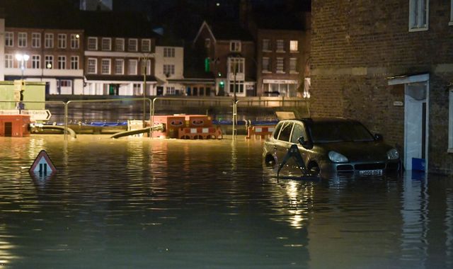
Water started to pour over the top of the temporary defences in Bewdley late on Tuesday night – and homes are being evacuated over fears that the river will not reach its peak until tonight.
The Environment Agency says the river at Bewdley is expected to reach between 5.4m and 5.6m, potentially surpassing the highest recorded level of 5.56m that was seen in November 2000.
As of 6.30am, there are two severe flood warnings in Shropshire – indicating a “danger to life” – covering the towns of Shrewsbury and Ironbridge.
According to the Environment Agency, river levels in Ironbridge are expected to remain high for several days.
Further showers are expected between now and Friday, and ongoing flooding is also forecast for the next few days.
Met Office forecaster John Griffiths has said between 5mm and 10mm could fall on the River Severn’s source, the Welsh hills, throughout Wednesday.
The West of England and the Midlands are expected to experience the most frequent showers.
An additional 5mm to 10mm of rain is forecast for most areas on Thursday – increasing to 10mm to 20mm in a 24-hour period between Friday and Saturday morning across catchment areas in Wales, Cumbria and Yorkshire.
On Tuesday night, residents in Bewdley said they felt “uneasy” as the Severn began to pour over the top of the flood defences.
Adrian Guest said: “I think the fact that the barrier has breached already and the peak is not forecast until this time tomorrow is affecting people’s resolve.
“It feels very different tonight compared to last week when it was originally due to come over last Tuesday.”
Further north, homes were evacuated on Tuesday after the River Aire burst its banks in Snaith, East Yorkshire.
Despite much of the land in the area being washlands – intended to contain river water when it floods – water submerged some roads and began to threaten properties.
Residents were warned by the Environment Agency to put their flood plans into action, although no further significant rainfall is expected there until Friday.
Caroline Douglass, director of incident management at the Environment Agency, said: “We are in our fourth week of exceptional river levels and stormy weather.
“With the effects of climate change, we need to prepare for more frequent periods of extreme weather like this.
“People need to be aware of their flood risk, sign up to flood warnings, make a flood plan and not to drive or walk through floodwater.”
England has seen more than twice its average February rainfall, and some areas have experienced a month’s worth of rain in 24 hours.
(c) Sky News 2020: Towns struggle with rising river levels as flood barriers are breached