
60mph winds forecast as thunder and wind warnings in place
Written by News on 10/08/2019
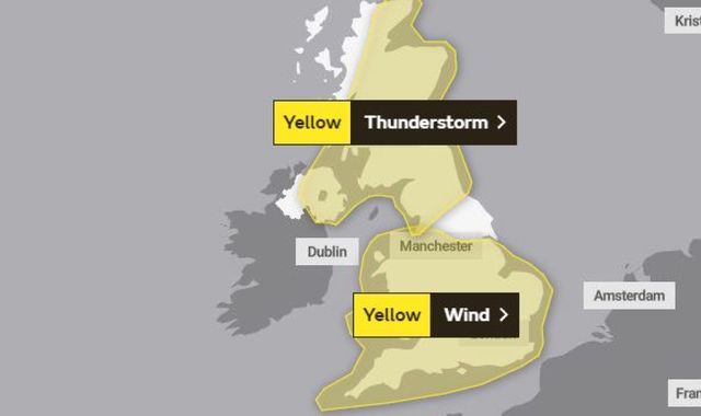
Thunderstorm and wind weather warnings for almost the entire UK have been issued for today, bringing with them the risk of power cuts and flooding.
Forecasters predict winds over 60mph could hit the coasts of Bristol Channel, the English Channel and through the Strait of Dover.
The Met Office has yellow thunderstorm warnings in place for Scotland, northern England and Northern Ireland, with forecasters predicting heavy showers and thunderstorms developing through Saturday and continuing into Sunday.
A statement from the weather office said: “Whilst many areas will miss the worst of these thundery showers, a few spots could see 15-25 mm within an hour and 30-40 mm within three hours.
“It is possible that some of these may become slow-moving and prolonged – most likely across parts of southern Scotland, leading to the potential for 60-80 mm of rain in six-12 hours.”
Meanwhile, a yellow wind warning is in place for England, from Cornwall to Manchester to East Anglia, and covering all of Wales.
Forecasters warned: “Unseasonably strong southwesterly winds are expected to cause some disruption, with gusts over 40 mph quite widely inland.
“Gusts over 50 mph are possible across parts of central and south-eastern England, particularly in association with showers.
“Gusts in excess of 60 mph are likely around coasts of Bristol Channel, English Channel and through the Strait of Dover.”
Those in the wind weather warning area could see delays to road, rail, air and ferry transport, with the potential for trees to be pushed over by the strong gusts. Forecasters also warned some residents may be hit with short-term power cuts.
The weather is expected to improve on Sunday, with the wind warning lifting. However, the thunderstorm warning for Scotland, Northern Ireland and parts of northern England is still in place.
It comes as heavy downpours have swept across much of the UK on Friday.
With the rain warning valid until midnight, Meteorologist Bonnie Diamond said: “There has been a lot of rain over the last 24 hours with more heavy showers to come on the way today and tomorrow.
“So we will certainly see an impact in terms of localised flooding, difficult driving conditions and transport delays.”
Ms Diamond said that between 9pm on Thursday and 9am on Friday, Antrim in Northern Ireland saw 39mm of rainfall – the largest amount in the 12-hour period. The country’s entire August average is just 97.4mm.
(c) Sky News 2019: 60mph winds forecast as thunder and wind warnings in place